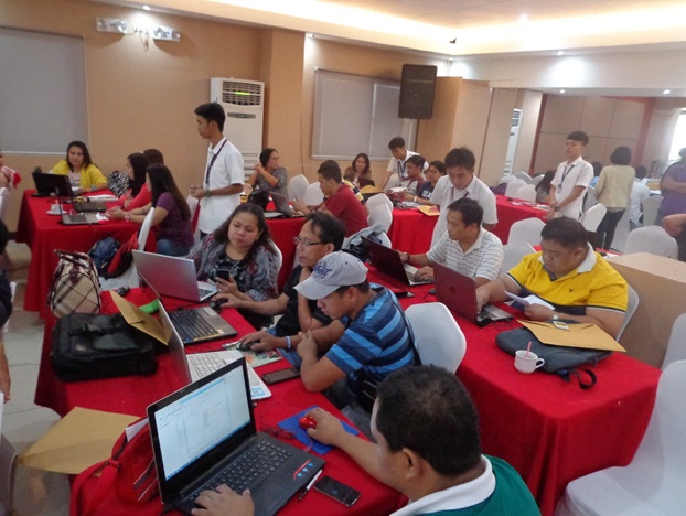
DISASTER RISK ASSESSMENT. Workshop participants work on their respective community maps with the aid of Geographic Information System. Supplied photo.
Xavier University’s Engineering Resource Center (XUERC), in partnership with the Provincial Planning and Development Office (PPDO), is currently conducting a workshop on Geographic Information System (GIS)-aided disaster risk, vulnerability and capacity assessment, which started on August 1 and will end on Friday, August 5.
The five-day workshop, held at Hotel Conchita in Cagayan de Oro City, is the fourth leg in the series of training sessions for the World Food Programme-funded project, “Strengthening the Capacity of the Disaster Risk Reduction and Management Office of the Province of Misamis Oriental.”
“In the first DRA (disaster risk assessment) training, the participants learned to map their communities using markers and manila papers,” recounted project head Engr Majiah Collado.
“This time, they combined the lessons from all three workshops, including the two GIS training sessions, to come up with actual maps that they can use in creating their DRRM plans,” she added.
XUERC has previously conducted three training sessions for the said project aimed at aiding 25 municipalities of Misamis Oriental in formulating their own disaster risk reduction and management plans.
PPDO selected the participants from the municipalities and members of the provincial, city, and municipal DRRM councils.
The first workshop was held from February 29 to March 2 this year, focused on introducing to the participants the basic concepts of disaster risk management and assessment. Grouped into teams, the participants mapped the exposed elements and hazards in their communities and identified the vulnerabilities in their areas.
The first workshop included a short introduction on GIS-aided disaster risk assessment.
Both the second and third workshops trained the participants in using the GIS software in mapping.
Members from the DRRM councils attended the first GIS training in April, while personnel from the municipalities joined the second GIS training in June.
XUERC designed the fourth workshop to fully integrate the concepts discussed from the three earlier sessions.
XUERC’s GIS specialist and main technical workshop facilitator Engr Jefferson Vallente Jr helped develop the workshop flow with inputs from Engr Dexter Lo, founding director of XUERC and overall project supervisor.
“We designed this DRA workshop to incorporate the themes of exposure, hazard, and vulnerability,” Vallente said. “Aside from including refreshers of the previous lectures, we also allotted ample time for intensive mapping sessions so that the participants can work on their maps.”
After the 5-day event, the output maps by the participants will then be used in the fifth session which is the writing workshop. ∎